Ablation Till
- Till laid down by melting ice, usually ice that has become stagnant.
- combination of englacial and supraglacial flow tills
- Thick, sandy and bouldary melt-out till
- Like basal till, but fewer fines, more gravelly, more angular, less dense, no fabric.
May have some stratification or lenses of water-borne sediments.
• NOTE: tills can easily be mixed up with colluvium!
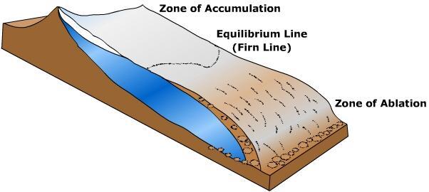
Ablation Zone
*The lower part of the glacier.
*Zone of an active glacier where more snow and ice is lost in summer than is gained in winter.
• Snow melts seasonally here → net deficit of ice.
*Distinguished from the accumulation zone.
*Loss of snow and ice due to melting in temperate regions, but also evaporation, calving, wind and river erosion, and sublimation.
• Negative mass balance: continuously shrinking, but fed by flow of ice from above.
(• Equilibrium line: separates accumulation and ablation zones.)
-transfer of mass from the accumulation and ablation zones maintains a constant or equilibrium surface gradient.
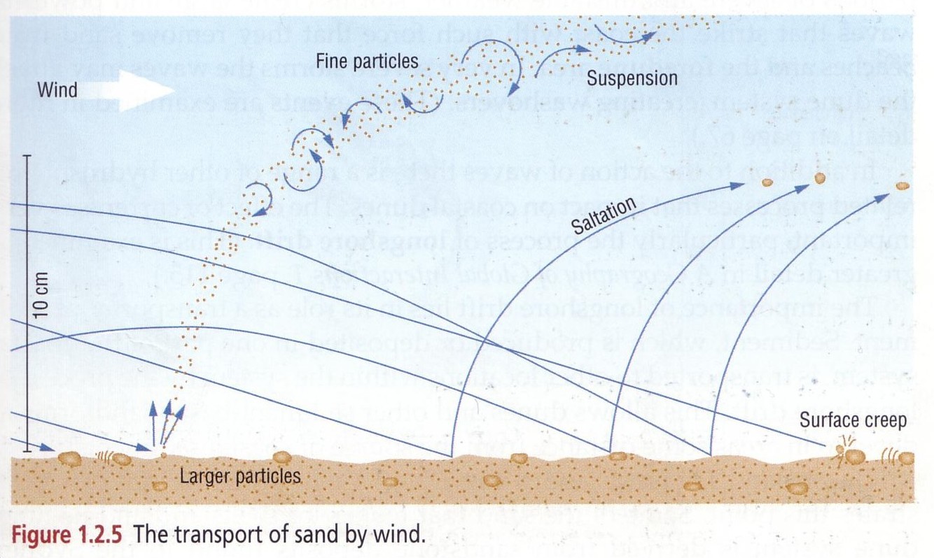
Abrasion (Aeolian)
- Most probable mechanisms for dust generation in deserts
- The grinding or wearing action of sand and other material carried by the wind against rock surfaces
- Limited to the ability of the wind to lift abrasive sand in saltation
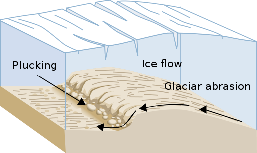
Abrasion (Glacial)
• Scouring of rock by glacial ice and embedded sediment (clasts)
- As clasts are move in traction, their edges and corners cut striations, while the finer abrasives polish the underlying rock surface.
- meltwater is responsible for transporting abrasive materials (along with going along with the glacier itself)
- Rates of abration may be greatest with low debris concentrations.
Rates of abration depend on frequency of contract between abrasic materials and bedrock, hardness of abrasives relative to bed, and the downward force exerted on the abrasives.
-Big angular clasts are most effective
• Rates of up to 5 mm/yr have been determined.
- Highest pressure in front of the slope, and lowest behind it.
- Cold based ice does not allow for much abrasion - and even protects the bed (because abrasion requires the presence of water) - Warm based ice is much more effective..
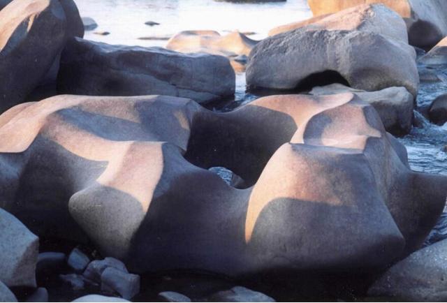
Abrasion (Rock Coasts)
Rock fragments and sand are swept, rolled, dragged over or thrown against rock surfaces
-Cylindrical depressions (potholes) develop where large clasts are rotated by swirling water inthe surf or breaker zones.
Accumulation Zone
*The upper part of an active, moving glacier.
• Positive mass balance: surplus of snow and ice here force the glacier to move downhill.
*snowfall accumulates and exceeds the losses from ablation
• Firn survives the summer.
(- Continental Glaciers grow outward from accumulation zones)

Aeolian Erosion processes
Abrasion
Deflation
Aeolian Transport
*** FIGURE 12.3 IN TEXT
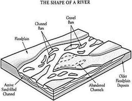
Aggradation
- To build up the floor or slope of a river by deposition. Slopes built up in this way are described as aggradational
- Increasing amounts of sediment cause single channels to widen and aggrade, promoting braiding
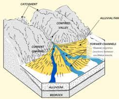
Alluvial Fans
• Sloping, fan-shaped deposits built upon the floodplain of a larger river.
• Stream often splits into multiple distributary channels.
• Typically occur where streams leave steep mountain valleys and enter a larger, main river valley.
*upper fan is the youngest
*consists of sand and gravel
*Cone shaped,

Alluvium
Fluvial sediments: Valleys often have a fill of this stuff: a combination of bar and floodplain deposits
-Sediment deposited by rivers and consisting largely of sand, silt and clay
Alpine Erosional Landforms
**FIGURE 7.8 & 7.9 IN TEXT
- Cirques
- Gacial troughs
- Hanging valleys
- Truncated spurs
- Fjords
- Aretes
- Horn
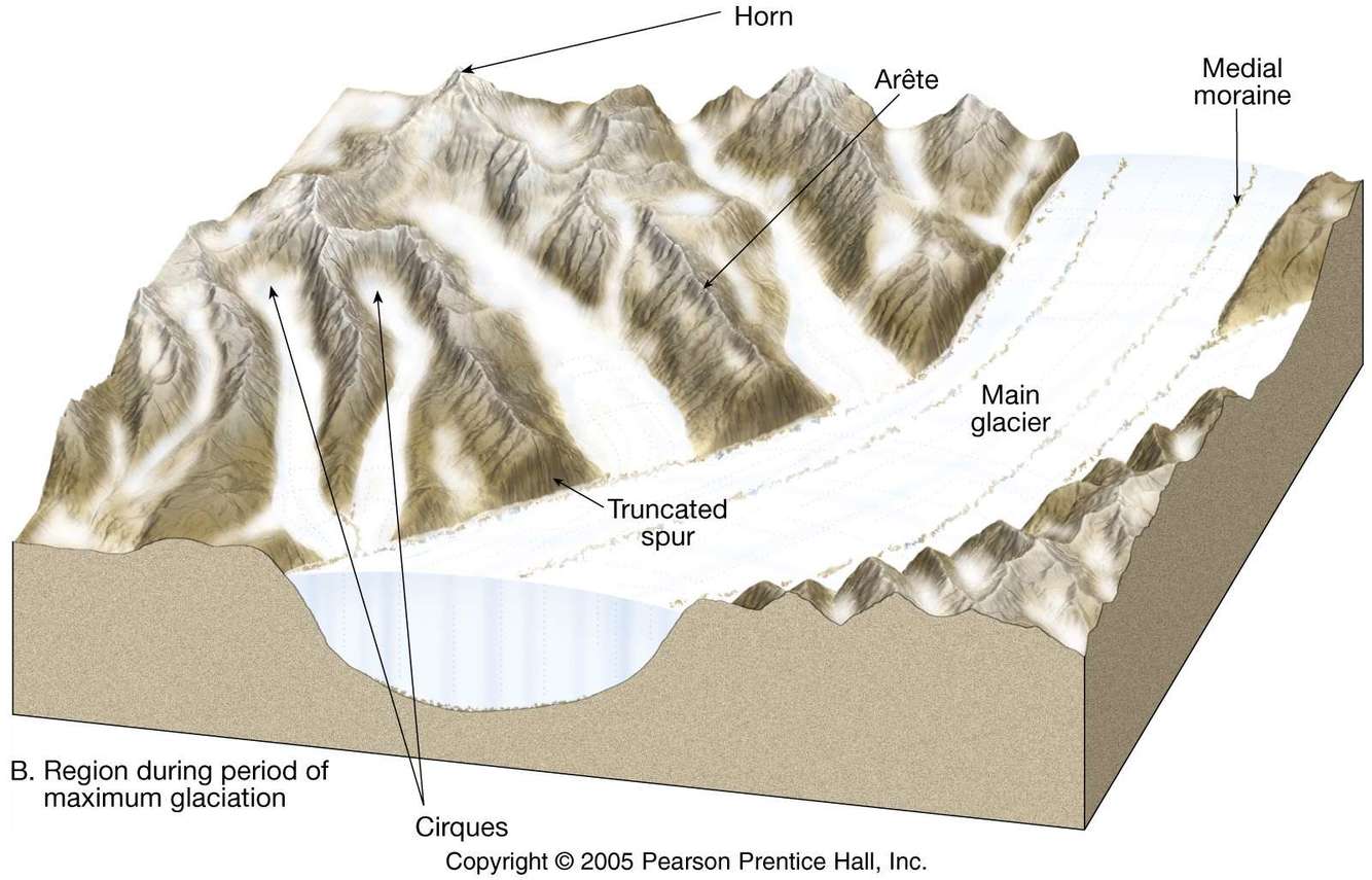
Alpine Glaciers
- Long and narrow mountain glaciers which fill / carve valleys or ‘troughs’.
- Begin as “pocket glaciers” in high alpine bowls.
- Flow together like streams.
- Coalesce into piedmont glaciers when they leave the mountains.
(May feed continental glaciers, if fringes are mountainous)
(landforms are similar for both alpine glaciers and ice caps/sheets, though dimensions will differ..)
PAGE 229 for picture.. coooool.
Amplification
*Shaking levels at a site may be increased, or amplified, by focusing of seismic energy caused by the geometry of the sediment velocity structure, such as basin subsurface topography, or by surface topography.
*Two important local geologic factors that affect the level of shaking experienced in earthquakes are (1) the softness of the surface rocks and (2) the thickness of surface sediments.
Anabrancing
- Multiple, stable, low-sinuosity channels.
- Well developed levees, many vegetated islands.
- Floodplain relatively distinct
*consists of two or more fairly deep and narrow interconnected sand or gravel channels that enclose floodplain areas
*Similar to braided rivers, except these are separated by prominant natural levees, wetlands, ponds and vetegated semi-permanent islands. Also the islands are much larger than the channels, where in braided, they are similar to the size of the channel.
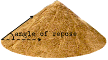
Angle of Repose (or internal friction)
The steepest surface gradient of loose sediment. The mass angle of repose ranges from about 32-35 degrees, generally increasing with diminishing grain size and decreasing sphericity. Individual grains, however, can have much higher angles of repose.
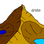
Arete
• Sharp-crested ridges acting as the divide between two glaciated areas.
Barchan dunes
- crescent-shaped features, horns point downwind.
- ~1 m to 100’s of m from horn to horn.
- unidirectional winds.
- Indicates that strong, competent, frequent winds
- form where sand supply is limited, and they are the fastest migrating form
*Little vegetation in the area
*Aeolian transport is more rapid across and around the sides of patches or mounds of sand than across the centres, where sand is the thickest.

Barchanoid ridges
- Barchans frequently occur in coalesced forms called barchanoid ridges
- oriented perpendicular to the wind direction.
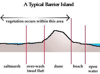
Barrier islands
**FIGURE 14.4 IN TEXT
Coastal landscape
- Depositional landform
- vulernable to subsidence, erosion and rising sea levels
*Long narrow beach forms completely separated or detached from the mainland
-Enclose estuaries, emayments or narrow lagoons that are connected to the open sea through cannels or tidal inlets between the islands
*Some shift landward and some along the shore (due to longshore transport)
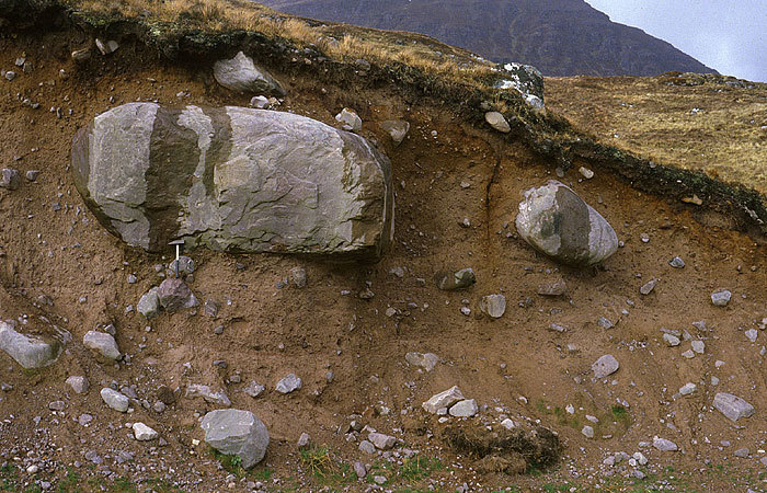
Basal Till (lodgement till)
Glacial sediemtn deposit
*Till that has been carried or depoisited a the bottom of the ice
*Dense and overconsolidated, often dominantly fine-grained, and with clasts that have rounded edges and sometimes striated or faceted surfaces.
*Have distinct till fabric, sometimes with stone dipping gently upglacier, in accordance with the direction of maximum stress.
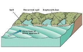
Baymouth barriers
Coastal Landscape
-Depositional feature as a result of longshore drift.
*A spit that completely closes access to a bay, sealing it off from the main body of water.
*usually consist of accumulated gravel and sand carried by the current of longshore drift and deposited at a less turbulent part of the current.
*
commonly occur across artificial bay and river entrances due to the loss of kinetic energy in the current after wave refraction.
Bedload transport
Fluvial sedimentary process (transport)
– Almost entirely function of flow volume, velocity and turbulence
– Sand and coarse particles roll, slide and saltate (jump) at constant rate unless obstructed
– Increase in flow strength causes entrainment and a fall in velocity causes deposition
*Much slower than the flow velocity
*Sediment becomes finer downriver because size sorting in bed load and, to a lesser extent, because of abrasion and particle breakdown. Because of this, bed load becomes increasingly secondary to suspended load down the course of the river
Braided
River Channel Pattern
• Typical conditions:
o Erratic (flashy) discharge.
o Steep slope, low sinuosity.
o Relatively coarse bed material (> sand)
o High sediment load.
*Most common in high latitudes
*Very common at glacier outwash deposits
• Some characteristics:
o Multiple small, shallow channels.
o Many bars.
o Highly unstable.
*One or more channels are usually dominant in large braided rivers