What is flight visibility?
- Flight: ability to see and identify proinent unlighted objects by day and prominent lighted objects at night
What are PIREPs? when do we use them?
a voice report given to ATC while airborne for the purpose of advising other aviators of potential hazards
- Required when:
- requested by ATC
- unusual or unforeseen weather conditions are encountered
- weather conditions on IFR approach differ from the latest observation
- when a missed approach is executed
- when wind shear is encountered on departure or arrival
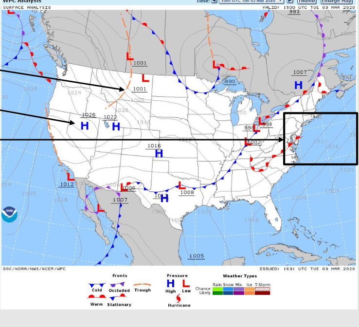
What are Surface Analysis Charts?
When do we use them?
Surface Analysis Charts
Display trough, pressure centers, isobars (4 millibar spacing)
Represent past
Look at the pic
identify high/low pressure fronts
Stationary front
Occluded fronts
What are Weather Prognostic Charts?
When do we use them?
Prognostic charts
- forecast conditions
- VFR vs IFR
- Big picture planning
on a TAF, what do the following represent?
FM:
BECMG
TEMPO
- FM: Rapid, permanent change
- BECMG: Gradual change in predominant conditions by end time listed
- only the changed elements will be listed and will be the new forecast weather until the end of the TAF unless unless changed later by another group
- we only care about the second time
- TEMPO: temporary condition
- only certain items updated
- expires at the end of period listed
- reverts ot previous line or when superseded by subsequent line
How do we use TAFs in flight planning?
Terminal Aerodrome Forecast
Forcast for >24 hours of conditions
use to determine destination weather
What are Winds-Aloft Forecasts?
when do we use them?
helps with selection of altitude during flight
*I wish I could tell you more about reading these…
What is ground based weather Radar?
radar senses reflectivity.
anything 55 db or higher indicates hail
Describe the use of satellite imaggery
shows cloud cover
What are Severe Weather Watch messages?
boils down to:
DON’T FLY IN THIS
What is vertical visibility?
VV is the distance seen directly upward from the ground in a total obscuration
- Used when:
- sky is totally hidden
- base within 50’ of surface
*greatly affects Slant Range Visibility
**referred to as an “indefinate Ceiling”
SIGMET
Convective:
Non-Convective
SIGMET
issued for 4 hours
- Convective- thunderstorm related
- implies severe or greater turbulence, severe icing, and low level wind shear
- Non-Convective SIGMET- not thunderstorm related
- severe icing
- severe or extreme turbulence
- dust/sand storms reducing visibility to <3 miles
- volcanic ash
What is Prevailing Visibility
Prevailing: Greatest horizontal visibility throughout at least half of the horizon circle (visibility does not need to be contiguous)
What is Slant range visibility?
slant range: distance on final approach when the runway environment is in sight
What is Runway visual range (RVR)?
runway visual range (RVR) horizontal distance looking down the runway
What type of cloud cover do we care about with ceilings?
Broken or overcast
Broken = 5/8-7/8 of sky covered with clouds
Overcast = 8/8 of sky with clouds
**The ceiling is the lowest broken or overcast layer
When are PIREPS required:
- requested by ATC
- unususal or unforseen weather conditions
- when on an IFR approach and the weather conditions are different from the latest observation
- missed approach is executed
- wind shear is encountered
What type of weather is associated with a Convective SIGMET?
How often are they issued?
how long are they valid?
Convective SIGMET
Thunderstorm related (but not the most severe of thunderstorms), SEVERE or greater turbulence, SEVERE icing, LLWS
issued hourly at hour+55
valid up to 2 hours
What type of weather is associated with a
Non- Convective SIGMET?
Non-Convective SIGMET
SEVERE icing/turbulence not related to a thunderstorm
dust/sand storms that lower visibility to <3 SM
Volcanic Ash
*issued every 4 hours
How far apart are the isobars on a surface analysis chart?
4 millibar spacing
*purpose of a surface chart is to show pressure
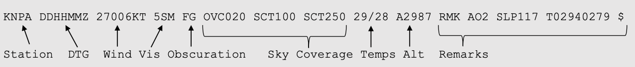
What is METAR?
when do we use it?
“current conditions”
use METAR for criteria for take off
Given the METAR Below
what are the winds at KNPA?

Winds are the third set of numbers
270/06
-
Aerodynamics59
-
Engines42
-
Engines 233
-
Engines- Electrical Systems47
-
Engines- Study Questions37
-
Flight Rules and Regulations Chapter 124
-
Flight Rules and Regulations- Chapter 229
-
Flight Rules and Regulations- Chapter 337
-
Whether the Weather- chapter 124
-
Weather- Chapter 2-354
-
Weather Chapter 422
